
Yaojia Fm
Type Locality and Naming
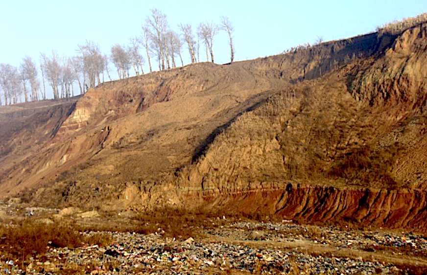
Songliao Basin. The Yaojia Formation was erected by the second Petroleum Prospecting Brigade under the Ministry of Geology and Mineral Resources. The section for the designation is at the Yaojia railway station south of the second Songhua river bridge of the Dehui County of Jilin. The reference section is down the well No.pu-1 of the Anda County of Heilongjiang. Middle formation (4 of 7) in the Songhuajiang Gr.
[Figure: Type section of Yaojia Formation near second Songhua river bridge of Dehui County, Jilin]
Lithology and Thickness
The Yaojia Formation is dominated by brown red and dark purple red mudstone and silty mudstone. In the central part of the Songliao Basin, it shows a set of gray, grayish green and gray black sandy mudstone. It is divided in ascending order into three members. First member is built up by gray and gray green mudstone and silty mudstone with siltstone and fine sandstone, with gray black mudstone appearing in the upper part; Second and Third members are dominated by gray black mudstone with shale and ostracod beds. It is 173.5 m thick.
Relationships and Distribution
Lower contact
The conformable base of the formation marked by gray mudstone, siltstone and fine sandstone is bounded by black mudstone of the underlying Qingshankou Fm.
Upper contact
The conformable top is bounded by the appearance of gray black mudstone with poor quality oil shale of the Nenjiang Fm.
Regional extent
The present formation is distributed along the line linking Yushu-Xiaonan- west of Changchun-west of Gongzhuling of Nongan county of Jilin, dominated by brown red and dark purple red mudstone and silty mudstone. In the Wutaizi-Kalun area of the Huaide County, brown yellow sandy conglomerate with purple red mudstone are observed on the surface. In the Daqingzuizi area of the Dehui County, the formation is built up by brown red with gray green microclastic rocks, with a thickness of only 5 m. In the Changling area, the formation is mainly built up by gray green and gray black mudstone with siltstone and small amounts of brown red mudstone, with an increase of thickness from south to north. In the Baicheng area, it is built up by gray green and brown red mudstone and clayey siltstone, with limy nodules and boulder-clay, which is thin in the west and thick in the east. The present formation occurs throughout the Heilongjiang province, except in Nenjiang-Dude of north Heilongjiang. The first member is built up by gray black and gray green mudstone interbedded with sandstone in Gulong and Putaohua at the center of the basin; brown red and gray green mudstone with siltstone towards east and southeast; and becomes coarser and is built up by gray white and gray green sandstone interbedded with gray green, brown red and gray black mudstone towards north and west. It is 61-73 m at the center of the basin, 6-13 m in the west, and 14-45 m in other areas. The second and third members are represented by brown red and gray green mudstone with gray white and gray green fine sandstone in the northern part; and dominated by gray green sandy mudstone with gompholite at the base. It is 60-100 m thick in the central part of the basin; 86-97 m in the Chaoyanggou area in the eastern part of the basin, 17-33 m in the western part, and 35-80 m in other areas.
GeoJSON
Fossils
The formation is a major source bed in the region. It bears ostracods Cypridea exornata, Lycopterocypris sp., Ziziphocypris rugosa; down the well No.sa-195 Cypridea tera, C.songhuajiangensis, C. infidelis; estherias Palaeolimnodiopsis andaensis; down the well No.du-402 bivalves Plicatounio (P.) latiplicata, P. (Kwanmonia) helongjiangensis.
Age
Depositional setting
It belongs to deep and relatively deep lacustrine sediments at the center of the basin; shallow lacustrine and shoal facies towards east and south; and shallow lacustrine-delta facies towards north and west.
Additional Information